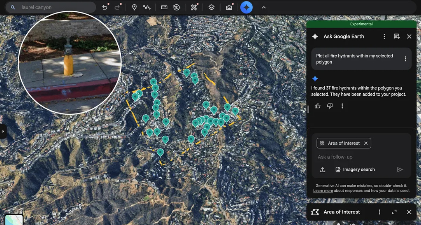
Google has expanded the capabilities of its Ask Google Earth platform, giving users new tools to identify, locate, and analyze municipal infrastructure across cities and defined geographic areas — a move the company says could improve planning efficiency and data-driven decision-making.

The updated feature enables users to pinpoint a wide range of infrastructure assets, including fire hydrants, speed limit signs, stop signs, street lights, traffic signals, utility poles, storm drains, and manhole covers. The system also allows users to view imagery sourced from Google Street View to assess asset condition and placement.
“Users can also access images pulled from Google’s Street View ‘to identify, detect, and see the condition of key infrastructure objects, like utility poles, street signs, roads, and bridges,’” the company said.
The enhancement builds on Google’s decision to move its infrastructure datasets into BigQuery, the company’s AI-powered data analytics platform. By combining geospatial data with imagery and analytics, the tool is designed to streamline workflows for city planners, engineers, and public works departments.
The launch comes as U.S. infrastructure conditions show modest improvement but ongoing funding challenges. The American Society of Civil Engineers awarded U.S. infrastructure a C grade in its most recent report card — the highest score the country has ever received, but still below satisfactory.
At the same time, infrastructure has slipped down the list of mayoral priorities. According to a 2025 National League of Cities survey, infrastructure fell to fourth place after typically ranking among the top two concerns for city leaders.
That shift reflects mounting fiscal pressures, including tariffs, bond market constraints, and declining federal funding streams, according to experts.
“But if it is, it’s not a good sign,” said Farhad Omeyr, director of research and data for the National League of Cities. “Just because there’s no longer money, it’s not like these issues are suddenly fixed.”
As cities tighten budgets, Google is positioning Ask Google Earth as a way to help municipalities stretch limited resources by improving asset visibility and maintenance planning.
“For example, if you are a city planner needing to determine your annual budget for road sign repairs, Imagery Insights can help you identify the exact number and locations of signs requiring attention using Street View imagery,” the company stated. “This integration streamlines operations, optimizes workflows, and enables smarter, data-driven decisions for improved planning and operational efficiency.”
Urban planners and infrastructure managers can use the tool to conduct asset inventories, identify maintenance backlogs, and prioritize repairs — potentially reducing the need for costly manual surveys.
Originally reported by Smart Cities Dive, the update highlights how AI-powered geospatial tools are increasingly being applied to public-sector challenges. As cities face aging infrastructure, climate-related risks, and workforce shortages, digital mapping and analytics platforms are becoming central to long-term planning strategies.
By making infrastructure data more accessible and visual, Google’s Ask Google Earth feature may help local governments bridge information gaps — even as funding pressures persist.
Originally reported by Ryan Kushner, Editor in Construction Dive.