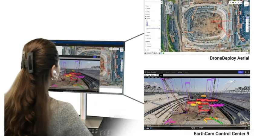
EarthCam and DroneDeploy — two leaders in visual intelligence and aerial reality capture — are teaming up to deliver a more complete view of construction progress. The companies announced a new integration on Oct. 29 that synchronizes EarthCam’s Control Center platform with DroneDeploy’s unified reality capture environment, giving project teams fully connected aerial and ground-level intelligence in real time.
The combined workflow brings together live-streaming video, gigapixel panoramas, orthomosaic maps, 360º site documentation and AI-powered analytics — all available in one interface designed for faster verification, safer operations and more transparent communication.
“By combining DroneDeploy’s imagery with EarthCam’s live content, users gain a valuable, multi-perspective view of their jobsite productivity,” said Brian Cury, CEO and founder of EarthCam. “This unified perspective ensures every event is captured, from detailed archived aerial photos to live views, for continuous progress monitoring, safety and security.”

Contractors already piloting the integration emphasize its immediate benefits for coordination and unit accountability on major builds.
“The integration is about connecting the dots between what’s captured in the air and what’s happening on the ground. It’s helped improve coordination and accountability across our teams,” said Grant Barton, CM-BIM VDC Engineer at the Tennessee Builders Alliance, which is constructing the Tennessee Titans’ new stadium.
Two-Way Data Flow for Real-Time Visibility
Users can now move seamlessly between DroneDeploy’s aerial maps and EarthCam’s ground recording — with automatic synchronization that ensures visuals are constantly up to date. This eliminates the manual transfer and labeling often required between platforms.
“Our customers want all their data in one place,” said Mike Winn, CEO and co-founder of DroneDeploy. “Combining visual data from fixed cameras with drone and handheld camera imagery democratizes data across the workforce, enabling better decision making on all their projects. The integration of EarthCam’s imagery expands our platform’s existing air and ground viewports, delivering the most complete reality capture experience available.”
Key advantages of the partnership include:
- Seamless Data Sharing — DroneDeploy aerial imagery syncs into EarthCam Control Center 9 for faster documentation and issue detection.
- Centralized Visibility — Live cameras, panoramas and time-lapses combine with drone and 360º capture in both systems.
- Faster Setup — Simplified configuration reduces onboarding effort and accelerates adoption across field teams.
Construction firms, infrastructure developers and A/E/C professionals using either platform can activate the integration immediately.
Why it matters now
- Major contractors are rapidly scaling digital workflows to counter labor shortages and risk exposure.
- Visual verification is increasingly required in compliance, billing validation, progress documentation and dispute resolution.
- AI-enhanced capture reduces the time traditionally spent walking large sites while increasing safety by reducing exposure to hazardous areas.
Market impact
- The integration supports the shift toward data-driven jobsite management, where stakeholders can instantly confirm installation status, material placement, weather delays and schedule impacts.
- Cloud-connected imagery strengthens collaboration for remote owners, lenders and insurers who want transparent oversight.
Future-ready tech stack
Industry analysts see this partnership as a cornerstone in evolving jobsite automation — potentially linking live visuals directly with robotics deployment, BIM and predictive scheduling software.
Originally reported by Earthcam. Inc in Construction Dive.